NTH Consultants
Contact Us
  • Home
  • Markets
    • Energy Market
    • Industry Market
    • Water Market
    • Transportation
    • Community Development
  • Services
    • Geotechnical Engineering >
      • Geophysical Services
      • Mapping
      • Shoreline Services
      • Civil Site Engineering and Design
      • Construction Materials & Geotechnical Testing Services
      • Electric Substation Services
      • Geotechnical Engineering for Transportation Facilities
      • Underground Engineering Services
      • Subsurface Utility
      • Signature Projects
    • Environmental Services >
      • PFAS
      • Ecological Services
      • Environmental Health Services
      • Environmental Remediation Services
      • Environmental Compliance
      • Environmental Permitting
      • Environmental Site Assessments
      • Ecological Services for the Energy Market
      • Air Quality Permitting and Compliance
      • Brownfield Site Redevelopment
      • Environmental, Health & Safety Training for Employee Development
      • Hydrogeologic Studies
      • Landfill Related Services
      • Site Acquisition and Redevelopment
      • Storage Tank Services
      • Signature Projects
    • Facilities Engineering >
      • Decommissioning
      • Structural Condition Assessment Rehab
      • Bridge Engineering Services
      • Asset Management Services
      • Concrete Restoration
      • GIS Services
      • Masonry Evaluation Services
      • Pavement Engineering and Consulting
      • Roofing Technology Services
      • Structural Condition Assessment
      • Signature Projects
  • Projects
  • About Us
    • Mission + Core Values
    • Leadership
    • News and Events
    • Employee Portal
  • Webinars
    • Emergency Actions Plans Webinar
  • Careers
    • Why Join NTH
    • Who We Are
    • Career Opportunities
    • NTH Internship Program
  • Blog
  • Contact Us

Spatial is Special

10/27/2015

3 Comments

 
The Increasing Role of Geographic Information Systems (GIS) in Civil Engineering
Picture
By Jeffrey Kodysh, NTH Consultants
Picture
Civil engineering is an incredibly diverse discipline. Civil engineers work with a variety of infrastructures, from waterworks and flood protection systems to roads and bridges to pollution control and everything in between. Even though on the surface it might seem these various infrastructures have little in common, there is one shared factor binding them together – spatial location.

Each infrastructure asset we work with has a unique spatial location or set of locational coordinates. I-96 has a unique set of locational coordinates compared to every other highway and road in the world, and thus, I-96 is just one unique part of a much larger transportation network.

This concept of unique spatial location is a powerful one, as it allows a more complete understanding of the world around us. Engineers and scientists have latched onto this idea, and together with recent advancements in computational technology, are now using spatial analysis tools like Geographic Information Systems (GIS) to look at the world around them with fresh eyes. 

What is GIS?

GIS is more than just software for creating maps. GIS is, at its core, a computational tool allowing users to collect, organize, analyze, and visualize data spatially. GIS is a platform which allows users to ask “where?” and help bring locational relevancy to a particular question by framing the question in a spatial context. This enables people to more easily see, analyze, and understand complex patterns that might otherwise be overlooked.

For instance, a GIS could be created to map out a city’s underground water pipes and the respective pipe sizes, ages, and materials. Such a GIS would help users determine which water pipes are not up to code and in need of replacement. Factoring in the cost of replacement, the same GIS could then be used to analyze what specific pipes are most likely to fail and which pipes are most vital to the overall functioning of the water system. A GIS-based strategic management plan could then be created to ensure the most vital pipes are given priority in the upkeep of the system.

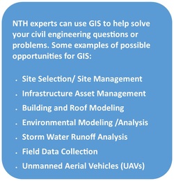
One of the most important aspects of GIS is that it can be used to collect, manage, and analyze nearly any sort of data. Data in a GIS is not just limited to satellite imagery and GPS points. There is almost no limit as to what sort of data a GIS can handle. 3D modeling, historical live data feeds, and “Big Data” type datasets are all potential inputs to a GIS.  (See examples below)

The Increasing Role of GIS in Civil Engineering
​

GIS is playing an increasing role in the world of civil engineering due to the strongly spatial nature of the discipline. It is a useful tool for the modern civil engineer, allowing us to better answer the all-important question of “where” in all of the diverse projects we work on. In addition, because of its unique asset management and analytical capabilities, GIS can also be used to achieve significant cost-savings within infrastructure-focused organizations, especially as those organizations move away from paper-based asset management systems and into the digital world.

The concept of spatial location coupled with the development of GIS has revolutionized the tech industry over the past few years. In turn, these advancements will undoubtedly play a lead role in helping to bring locational relevancy to complex civil engineering questions as we move forward into the data age.

Picture
This is a screenshot of sewer data stored in a relational database. Databases are an excellent way to collect and store large amounts of data; however, humans are not computers. It is difficult for us to understand the context of what this data really means. Where are the manholes? Where are these sewers? How large are the pipes?
Picture
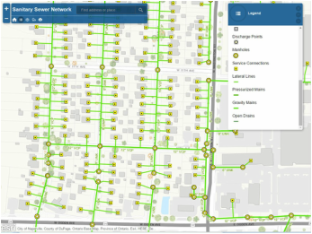
This is the same data visualized in a GIS format. The data now has spatial context and is easily understood from a human’s perspective. (Images created with data courtesy of ESRI Sanitary Sewer Model) 
3 Comments

Waters of the US Rule on Hold in Michigan

10/15/2015

0 Comments

 
Picture
U.S. Circuit Court of Appeals issued an order that temporarily blocks the Waters of the US Rule for Michigan and 17 other states while the Court considers a jurisdictional issue. The states have argued that the rule expands jurisdictional waters under the Clean Water Act to include all tributaries, wetlands, ponds and waters within a certain distance of a jurisdictional water at odds with the ruling in the Rapanos case. The states also argue that the rulemaking process itself was flawed. According to the Order, the Court is expected to rule on the jurisdictional issue within a matter of weeks.

The extent of jurisdictional authority of the US Army Corps of Engineers and the Michigan Department of Environmental Quality over the various waterways, watercourses, and wetlands of Michigan has been a hotly debated topic since the Clean Water Act was adopted in 1972.  Both private property owners and County Drain Commissioners have questioned the application and interpretation of what defines “waters of the United States.”  This impacts both the type of work and the cost of work to modify or maintain a County Drain or certain types of private property, and has even resulted in private property owners facing substantial criminal and civil penalties.
 
In June of this year, “The Clean Water Rule” 80 Fed. Reg. 37,054 was meant to clarify the definition of “waters of the United States,” as used in the Clean Water Act “to make the process of identifying waters protected under the Clean Water Act easier to understand…”  Eighteen states oppose the new definition and resulting expanded Federal jurisdiction, arguing that the new rule is not consistent with past precedent, namely the 2006 case, John R. Rapanos v. United States.  The Sixth U.S. Circuit Court of Appeals has issued a temporary hold Order on “The Clean Water Rule” while they rule on this jurisdictional rule.​


0 Comments

NTH Partners with Michigan Agriculture Environmental Assurance Program

10/15/2015

0 Comments

 
Picture
Michigan's Agriculture Environmental Assurance Program (MAEAP) is one way the Michigan Department of Agriculture and Rural Development (MDARD) and Michigan's agriculture industry is proactively addressing environmental concerns. MAEAP is a voluntary program designed by a coalition of farmers, agricultural commodity groups, state and federal agencies, and conservation and environmental groups to reduce producers' legal and environmental risks.
 

Recently, NTH Consultants, Ltd. was chosen to be a MAEAP partner. NTH sought MAEAP partnership status to demonstrate our commitment to Michigan’s agricultural industry, helping farmers efficiently maintain environmental stewardship using new technology.
 
MAEAP partners, such as NTH, commit to actions that positively promote the efforts of Michigan farms of all sizes and all commodities to voluntarily prevent or minimize agricultural pollution risks, to achieve MAEAP verification and to comply with state and federal environmental regulations.
 
A full list of all partner and supporters can be found here:
http://www.maeap.org/partners.

0 Comments

the Power of an Air Permit:                                                                                   How NTH Helped Get the Holland Energy Park off the Ground

10/9/2015

0 Comments

 
PictureBy Lori Myott, Vice-President, NTH Consultants, Ltd.
​From its conception, Holland Energy Park has been dubbed the Resource, Destination and Gateway for the Holland Community. But it was no easy road for the folks at Holland Board of Public Works (HBPW); a process that, in fact, would span nearly ten years. What emerged was a new 114 MW natural gas combined heat and power (CHP) plant and an agreement to purchase 17 MW of wind generation from the Beebe Wind Farm in Ithaca, MI. The new CHP will provide electricity, central district heating and snowmelt for the Holland community.
 
But before the first shovel, or bulldozer in this case, could hit the ground, an air use permit to install (a pre-construction permit) would need to be obtained.
 
​
​
Air Permit to Install
On April 26, 2013, NTH Consultants, Ltd. met with HBPW and HDR, Inc. (Owner’s Engineer) to discuss the air permitting requirements. Over a period of 12-weeks NTH worked closely with HDR as the facility design unfolded and new information was obtained. NTH calculated air emissions for several operational scenarios, including various turbine loads, startup, and shutdown; and evaluated applicable state and federal air quality regulations that may impact operation of the plant. An extensive air pollution control technology evaluation was also conducted.
 
Finally, NTH conducted a thorough ambient impact analysis using dispersion modeling techniques to determine concentrations of regulated air contaminants for comparison to health-based standards. Throughout the application development, NTH completed nearly 100 modeling runs at various exhaust stack locations and parameters, and operational scenarios to determine compliance with federal ambient air quality standards and state of Michigan air toxic health based screening levels.
 
The permit application was submitted on July 22, 2013 and a final air permit was approved by the MDEQ on December 4, 2013. NTH worked closely with MDEQ during the permit review process to ensure major milestones were met and that the project was moving forward. Typical air permitting timelines for projects of this magnitude can be anywhere from 6-18 months, but the MDEQ processed the HBPW permit application approximately less than 6-months from application submittal. This was due largely to the fact that during the public comment period, MDEQ did not receive any comments from the public, U.S. EPA or environmental groups, so they were able to quickly move forward with approval as soon as the comment period ended.   
 
A Community-Driven Project
The Holland Energy Park continues to be a community-driven project. The P21 website contains frequent news blogs to update the public on the latest information, live tracking of the turbine voyage from Finspång, Sweden to Holland, Michigan, and live video feed via webcams so that onlookers can catch real time progress on the construction of the plant. HBPW has also built an observation deck near the site allowing full public access. And when HBPW completely closed down streets from Verplank Dock to the construction site over a 4-day period to allow the massive 200-ton HRSG’s make their way to the site, an impromptu parade commenced as spectators lined the streets to watch and cheer.
 
The site is busy with trucks, bulldozers, excavators, and several cranes. Holes are being dug, foundations placed, pipes laid, concrete poured, steel framework erected, equipment delivered. 
 
None of it would be possible without the air permit! 

0 Comments

NTH Consultants M-5 fall Clean-Up

10/1/2015

0 Comments

 
 Since the mid-1990s, NTH has worked with Adopt-A-Highway to keep both sides of M-5 between Drake and Orchard Lake Roads in Farmington Hills clean of garbage and debris.  Adopt-A-Highway is a Michigan Department of Transportation (MDOT) program created to help keep our highway roadsides clean and attractive. 

Yesterday, NTH crews took to our stretch of the highway for a few hours of work and fun. It was a beautiful night to be outside working with our colleagues for this good cause!
0 Comments

    The NTH Narrator

    NTH Consultants, Ltd. (NTH) is a nationally recognized engineering firm specializing in Civil, Geotechnical, Environmental, and Facilities Engineering. 

    On our blog, our engineering experts address current news and events in our field, review new projects and highlight NTH news.

    Tweets by @nthconsultants

    RSS Feed

    Archives

    November 2022
    September 2022
    August 2022
    July 2022
    June 2022
    March 2022
    February 2022
    January 2022
    November 2021
    August 2021
    June 2021
    May 2021
    April 2021
    March 2021
    February 2021
    January 2021
    December 2020
    November 2020
    October 2020
    June 2020
    May 2020
    March 2020
    January 2020
    December 2019
    November 2019
    October 2019
    September 2019
    August 2019
    July 2019
    June 2019
    May 2019
    April 2019
    March 2019
    February 2019
    January 2019
    November 2018
    October 2018
    September 2018
    August 2018
    July 2018
    June 2018
    May 2018
    April 2018
    March 2018
    February 2018
    January 2018
    December 2017
    November 2017
    October 2017
    September 2017
    August 2017
    July 2017
    June 2017
    May 2017
    April 2017
    March 2017
    February 2017
    January 2017
    November 2016
    September 2016
    August 2016
    July 2016
    June 2016
    May 2016
    April 2016
    March 2016
    February 2016
    January 2016
    December 2015
    November 2015
    October 2015
    September 2015
    August 2015
    July 2015
    June 2015