 By Jeff Kodysh, GIS Analyst at NTH Consultants, Ltd
 One of the most important 20th century technological innovations was the American development of the Global Positioning System – or GPS for short. This system, consisting of a space-based constellation of approximately active 24 satellites beaming radio waves to the ground, allows users on the ground to accurately and precisely determine their location on earth’s surface. Originally intended for the military purposes, it has today blossomed into a key technology with an ever-growing list of end-users in fields as diverse as telecommunications to civil engineering.
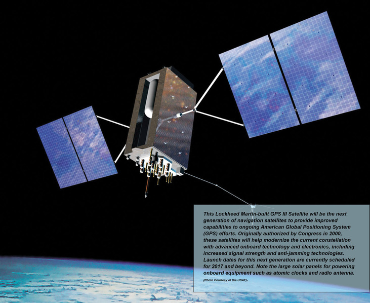
The world quite literally depends on GPS, and we aren’t going to abandon the system anytime soon. Besides its original defense purposes and the perhaps incalculable scientific value of being able to accurately say where something or someone is located on the earth, there are strong economic benefits to having a functioning GPS system. The government now estimates the economic value GPS system to be between $37.1 and $74.5 billion dollars, depending on how the calculations. This value will only continue to rise as GPS-using technologies become more and more ingrained our society via the use of smartphone applications and other geo-aware devices. In fact, GPS is so important to our daily lives that we have decided to invest billions of dollars into an improved GPS system called GPS III to replace our nation’s aging satellite constellation.
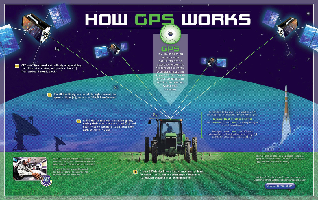
At its fundamental core, GPS is really quite a simple concept. It relies upon the known locations of the satellites in space and extremely accurate onboard atomic clocks to allow radio signal receiving units on the ground to “triangulate” locations based on this known information. The satellite constellation above the earth constantly broadcasts radio signals towards the earth’s surface with the current time and their position in relation to the earth. A receiver GPS unit on the ground captures these signals from multiple satellites and simultaneously solves for an unknown location using the precisely known locations of the satellites and the slight differences in radio signal travel times.
In reality, building, maintaining, and utilizing a functional, accurate GPS system is quite a bit more complicated than its theoretical fundamentals. It is a multibillion dollar technical endeavor involving dozens of different companies and is headed up by hundreds of scientists and engineers working with the United State Air Force.
A GPS provides accurate measurements at the planetary scale, with FAA data showing normal global civilian performance of the current system with approximately 3.8 meters of horizontal error as opposed to real life. This limitation occurs because of many different factors, including radio signal attenuation, interference from trees and buildings and other features, and the arrangement of satellites in the sky as related to the GPS receiver on the ground. Another large limiting factor for civilian applications of GPS is the fact that civilian users may only access one radio frequency versus two frequencies for military users.
This sort of accuracy is often more than enough for some applications – tracking a ship as it crosses the ocean, for example. 3.8 meter accuracy is not, however, good enough for applications of GPS technology that require centimeter or millimeter levels of accuracy, such as the precise grading of roadbeds.
Currently, civilian improvement of this accuracy is possible through the use of ground based technologies like the Nationwide Differential GPS (NDGPS) and the Continuously Operation Reference Stations (CORS) systems. These systems already allow for marked improvement of accuracy down to the millimeter level, but they have a large flaw in that they are not established evenly across the entire world. There are large “blind spots” where GPS can’t reliably deliver more accuracy than the previously mentioned 3.8 meter figure.
Our nation’s GPS capabilities will be markedly improved as the GPS III modernization process moves forward. Future improvements will allow civilian users to access multiple radio frequencies like military users, eliminating these blind spots. Additionally, GPS III will help usher in a system of signal standardization for incorporating other GPS constellations signals, like the EU’s Galileo GPS system. Altogether, GPS III will provide users with up to a three-fold improvement in accuracy, reduction of the ground-system dependent “blind spots”, along with vital improvements in anti-signal jamming technologies, a huge technological leap forward compared to current system.
The world quite literally depends on GPS, and we aren’t going to abandon the system anytime soon. Besides its original defense purposes and the perhaps incalculable scientific value of being able to accurately say where something or someone is located on the earth, there are strong economic benefits to having a functioning GPS system. The government now estimates the economic value GPS system to be between $37.1 and $74.5 billion dollars, depending on how the calculations. This value will only continue to rise as GPS-using technologies become more and more ingrained our society via the use of smartphone applications and other geo-aware devices. In fact, GPS is so important to our daily lives that we have decided to invest billions of dollars into an improved GPS system called GPS III to replace our nation’s aging satellite constellation.
At its fundamental core, GPS is really quite a simple concept. It relies upon the known locations of the satellites in space and extremely accurate onboard atomic clocks to allow radio signal receiving units on the ground to “triangulate” locations based on this known information. The satellite constellation above the earth constantly broadcasts radio signals towards the earth’s surface with the current time and their position in relation to the earth. A receiver GPS unit on the ground captures these signals from multiple satellites and simultaneously solves for an unknown location using the precisely known locations of the satellites and the slight differences in radio signal travel times.
In reality, building, maintaining, and utilizing a functional, accurate GPS system is quite a bit more complicated than its theoretical fundamentals. It is a multibillion dollar technical endeavor involving dozens of different companies and is headed up by hundreds of scientists and engineers working with the United State Air Force.
A GPS provides accurate measurements at the planetary scale, with FAA data showing normal global civilian performance of the current system with approximately 3.8 meters of horizontal error as opposed to real life. This limitation occurs because of many different factors, including radio signal attenuation, interference from trees and buildings and other features, and the arrangement of satellites in the sky as related to the GPS receiver on the ground. Another large limiting factor for civilian applications of GPS is the fact that civilian users may only access one radio frequency versus two frequencies for military users.
This sort of accuracy is often more than enough for some applications – tracking a ship as it crosses the ocean, for example. 3.8 meter accuracy is not, however, good enough for applications of GPS technology that require centimeter or millimeter levels of accuracy, such as the precise grading of roadbeds.
Currently, civilian improvement of this accuracy is possible through the use of ground based technologies like the Nationwide Differential GPS (NDGPS) and the Continuously Operation Reference Stations (CORS) systems. These systems already allow for marked improvement of accuracy down to the millimeter level, but they have a large flaw in that they are not established evenly across the entire world. There are large “blind spots” where GPS can’t reliably deliver more accuracy than the previously mentioned 3.8 meter figure.
Our nation’s GPS capabilities will be markedly improved as the GPS III modernization process moves forward. Future improvements will allow civilian users to access multiple radio frequencies like military users, eliminating these blind spots. Additionally, GPS III will help usher in a system of signal standardization for incorporating other GPS constellations signals, like the EU’s Galileo GPS system. Altogether, GPS III will provide users with up to a three-fold improvement in accuracy, reduction of the ground-system dependent “blind spots”, along with vital improvements in anti-signal jamming technologies, a huge technological leap forward compared to current system.
 RSS Feed